


20221001-Thuit Signol

doudet
User
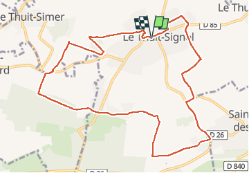

Length
11.5 km

Max alt
166 m

Uphill gradient
98 m
Km-Effort
12.8 km

Min alt
122 m

Downhill gradient
99 m
Boucle
Yes
Creation date :
2022-10-01 11:51:31.673
Updated on :
2022-10-01 17:08:22.433
3h25
Difficulty : Easy

FREE GPS app for hiking
 SityTrail
IGN / Geographical institutes
SityTrail Plus
The world is yours!
About
Trail Walking of 11.5 km to be discovered at Normandy, Eure, Le Thuit-de-l'Oison. This trail is proposed by doudet.
Description
Boucle A-R au départ de la Mairie de Thiot Signol
Photos


Positioning
Country:
France
Region :
Normandy
Department/Province :
Eure
Municipality :
Le Thuit-de-l'Oison
Location:
Unknown
Start:(Dec)
Start:(UTM)
349970 ; 5459001 (31U) N.
Comments
